Fingers crossed here. I’m running my last sets of masters probably for the week and trying to get them uploaded before the storm comes in. Its thundering pretty bad right now and hopefully my power stays on until they’re done bouncing. I have no idea how the studio building will hold up…this is the first storm we’ll have to deal with in the new location. Fingers crossed. (And insurance policies are paid up).
2 Likes
Did you plywood the windows?
I didn’t thinking that they’re bomb proof…
But I just realized that if you hit them with a grenade they crack like a windshield but hold together rather than shatter. Darn. I too late now.
I hope the storm goes around and misses your area!
Last bounce master is about 10 more min and counting now. Then gonna unhook my computers and get some stuff up on cinder blocks. Guitars going to the second story floor. The control room/tracking floors are marble and stone…they’ll be ok. Not worried about the cables in the underground conduits. They should dry out and be fine. Amps up stairs in the office/lobby.
I can hear that thunder coming. Just a few more min so I can get this mix handed in. Crazy.
Sending you good vibes!
Dang! Keep us posted!!
Stay safe and dry.
Hang in there J, this one is bad…If the current forecast tracks hold, you’ll be on the “good” side of the storm (SW quadrant), if one can use “good” for a cat 4 landfall (and it may even reach 5). The bigger issue for you is going to be the days following landfall, because high pressure aloft to the north of the storm is going to force Flo to slow down and possibly meander around after coming ashore. Forecasters have started calling it the “Harvey of the east coast” by analogy with what happened here last year. Could be several days of devastating rainfall. Here’s hoping she doesn’t stall out!!
Update: Latest official forecast of rain accumulations over the coming seven days:
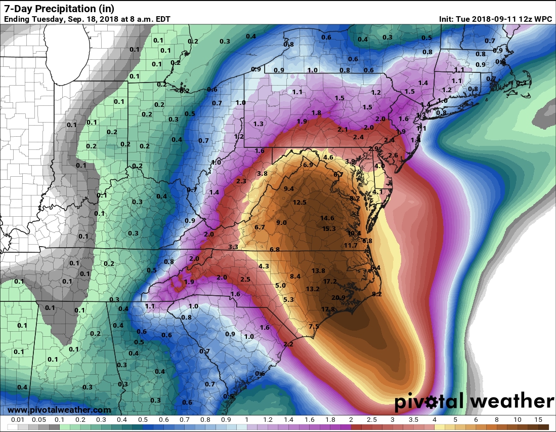
Accumulations in excess of 15" are likely in the coastal NC area! Fortunately you are in the periphery of this, but this forecast could still shift around depending on just what paths Flo takes if she stalls and wanders.
Highly recommend the Washington Post’s weather group, Capital Weather Gang, for updates. They’re a lot like our local guys, Space City Weather, in that they synthesize all the real data and deliver it with virtually zero hype. No Weather Channel breathlessness to try to drive ratings here, just the real story.
Where is Jonathan located? This one looks pretty bad. Hoping for the best and everyone stays safe.
Florence SC. Looks like its turning north…I shouldn’t be in the worst of it but as Dave said…we’re gonna get some rain.
1 Like
I guess the rains that started yesterday weren’t even part of the main storm…it was fairly dry today, but we’re getting ready for it to start pouring tomorrow.
Tomorrow won’t be Florence either. It’s still over 700 miles away as of mid-evening 11 Sep, moving at 17 mph, so tropical storm force winds won’t hit the coast until sometime Thursday. In Florence, not till the evening. There’s a band of rain parked between two stationary fronts that roughly parallel the coast, and that’s what you’ll get tomorrow.
Where you are, 30+ mph winds will pick up Thursday night, lasting roughly 48 hours before drifting back down to 20ish, and the heaviest rain will arrive about that same time, depending on how much meandering takes place.
Great site for your one-stop shopping of the latest data:
1 Like
Would you consider giving me my daily weather forecast after you retire? You’re awesome at it! 
2 Likes
Does Dave’s image look like a giant vagina coming to suck Jonathan up - or is it just me?
Sven
Aw, thanks. When I was an undergrad, my university had what they called an “emphasis phase”, not quite a minor, in a second subject, and mine was in meteorology. If I hadn’t been so smitten with geology, I’m sure I would have gone into meteorology and climate science… And living in hurricane country for so many years, you pretty much have to get knowledgeable. I have responsibilities at work in storm situations, directing the securing of labs and reporting on the safety of my folks and so on, so yeah, I keep myself well informed on this stuff!
2 Likes
Just a suggestion from a Brit, but have you considered just… not having Hurricanes? It’d be much easier, surely?
2 Likes
An eminently sensible idea! As it happens, I have personally made this suggestion multiple times, using all the powers of persuasion at my disposal and a wide variety of colorful metaphors. Inexplicably, my persistent entreaties have been ignored. The nerve…!
But seriously folks… some rather alarming developments in the Florence story from the most recent modeling. This storm has broken one precedent after another in its lifespan, particularly the fact that it will make landfall at all. Florence was at a location several days ago from which no storm of that size and intensity had EVER made US landfall before. In other words, every previous storm sitting where Florence was sitting at that time ended up “recurving” into the Atlantic and not threatening land, in our records going back to 1851.
When it does make landfall, it will be the strongest Atlantic storm ever to do so at a point so far north. It’s usually Florida that gets these (Sandy was a special case, combo of tropical remnants and a freak nor’easter). The next precedent broken is the very strong indication that Florence will stall after landfall, Harvey-like. Eastern seaboard hurricanes always (until now) just race up the coast after landfall, weakening steadily.
The latest model runs strongly indicate yet another unheard-of development: the storm is now forecast to take a LEFT turn after landfall instead of the usual right-hand turn, with tracks pointing southwest instead of northeast. Check this out: model runs just 36 hours apart, with the very latest on the right.
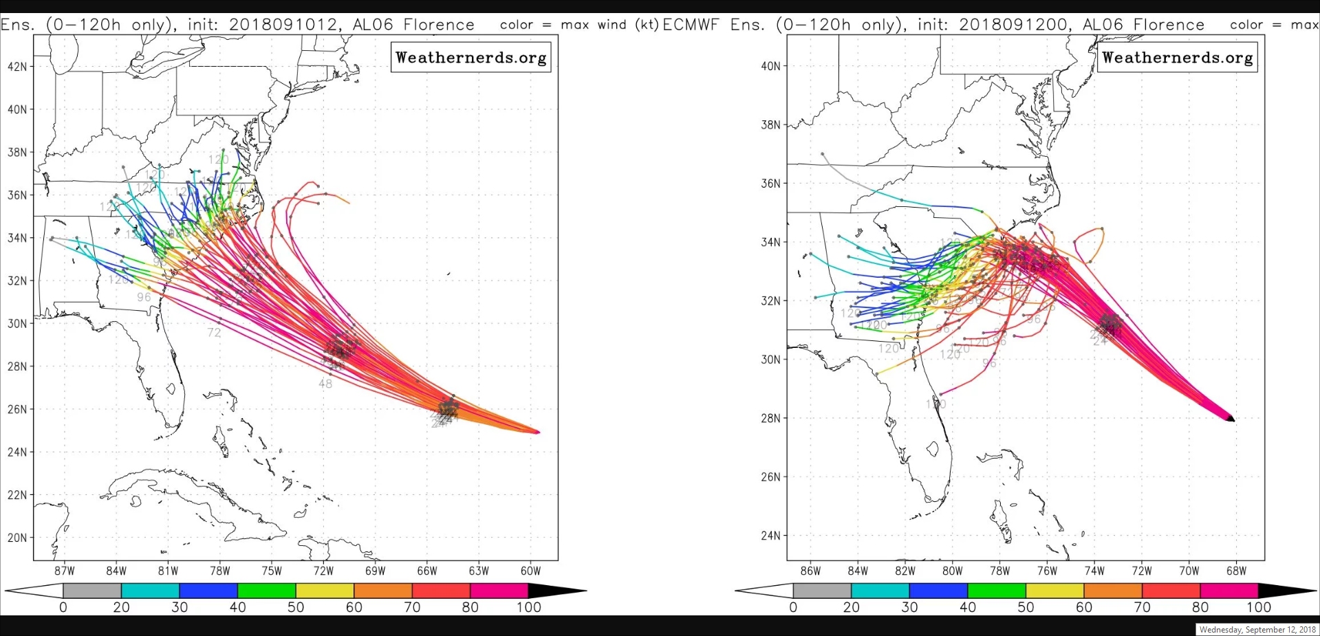
The tracks on the left are the usual sort of paths expected, with gradual turns to the northeast. But these latest models show the opposite, owing to the strength of the stubborn high-pressure ridge that has been steering Flo all this time. The tracks are labeled faintly with dots and numbers that correspond to the number of hours from the time the models were run for each dot. It’s a mess in the right hand plot because the dots are very close together-- meaning the storm is not moving much from one day to the next. That is BAD NEWS, it means the system is parking there just dumping rain. Exactly the Harvey scenario we endured here in Texas last year.
@Jonathan, I hope you see this! You need to pay VERY close attention to updates from your local weather people because there is a strong chance that really bad flooding could hit you in Florence SC (and points even further south, like where my wife’s family lives-- copying all this to them as well). For now, check out this piece in Ars Technica written by Eric Berger, the guy who founded the Space City Weather site that I mentioned in a post above-- for my money, the best in the business for describing what’s going on in detail with zero hype.
Wishing everyone out there luck and safety…!!
2 Likes